
TOKYO- All Nippon Airways or ANA (NH) and the Japan Aerospace Exploration Agency have launched the world’s first fully automated atmospheric observation system on scheduled commercial flights. The initiative integrates satellite-grade remote sensing technology into active airline operations.
The system is now operational on ANA flights departing from Tokyo Haneda Airport (HND), enabling continuous, high-resolution monitoring of greenhouse gases over urban regions without manual intervention.

ANA Launches World’s Fully Automated System
ANA Holdings Inc. and the Japan Aerospace Exploration Agency have achieved a global first by deploying an automated atmospheric composition monitoring system on scheduled commercial flights.
The project adapts advanced satellite remote sensing technology for permanent installation inside a commercial aircraft, allowing continuous data collection during routine operations.
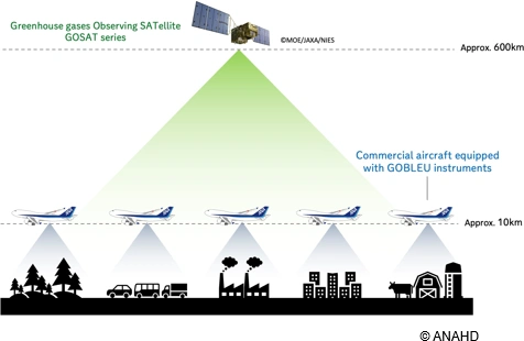
The initiative builds on joint research that began in September 2020. The focus has been on collecting precise atmospheric data from aircraft cabins, particularly over densely populated urban areas. These regions account for an estimated 70 to 80 percent of global human-generated carbon dioxide emissions, making them critical targets for accurate observation.
The technology is derived from JAXA’s Greenhouse Gases Observing Satellite, known as GOSAT or IBUKI, first launched in 2009. By transferring this proven satellite capability to aircraft platforms, the partners aim to capture granular, location-specific emissions data that satellites alone cannot consistently provide.

From Manual Tests to Continuous Operation
Earlier test flights required JAXA-developed equipment to be manually configured before each operation. This limited scalability and operational efficiency. The new system removes that constraint.
The observation equipment is now permanently integrated into a modified section of an ANA Boeing 737 cabin.
Automation enables uninterrupted operation across regular commercial flights without additional crew workload or flight disruption. This marks the first time satellite-based atmospheric sensing has been fully automated within scheduled airline services.
The combined use of wide-area satellite observation and high-frequency aircraft data creates a more accurate and resilient monitoring network. Aircraft-based measurements offer higher spatial resolution, while satellite data provides broader atmospheric context.
Supporting Urban Emission Reduction Goals
The data collected through this system supports detailed analysis of urban greenhouse gas emissions and the effectiveness of mitigation measures.
The results contribute directly to international climate frameworks, including the goals set under the Paris Agreement.
ANA and JAXA plan to expand the range of observed datasets over time. The objective is to develop data-driven services for international organizations, national governments, private enterprises, and local authorities. These datasets are intended to provide scientific evidence for policy decisions and emissions reduction strategies.
Expanding Beyond Atmospheric Observation
Future research will extend beyond greenhouse gas monitoring. By combining aviation platforms with space-based systems, ANA and JAXA aim to address broader global challenges, including environmental monitoring and climate resilience.
The partnership also includes the development of technologies that collect Global Navigation Satellite System data alongside atmospheric measurements. This improves positional accuracy and enhances the reliability of observed data.
Stay tuned with us. Further, follow us on social media for the latest updates.
Join us on Telegram Group for the Latest Aviation Updates. Subsequently, follow us on Google News